For Much of U.S., Above Average Temperatures to Continue

Much of the United States is expected to be warmer as we close out summer and head into autumn. Some drought relief may also be on the way for parts of the southeast and desert southwest. Read on for more information.
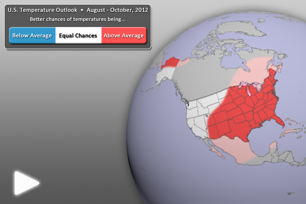
U.S. Temperature Outlook (August-October 2012)

U.S. Temperature Outlook (August-October 2012) • Click Image for Full-Earth animation • Click Here to open in YouTube

  • Sea Surface Temperatures in the ENSO (El Niño Southern Oscillation) region suggest continued neutral conditions, but may be giving way to an El Niño by the end of the summer or early fall, according to the Climate Prediction Center.
  • For the August – October period, warmer than normal temperatures are expected across much of the eastern two-thirds of the United States, as well as northern Alaska. Low soil moisture amounts across much of the country also continue to keep much of the country warmer than normal.
  • All other locations (in white) have equal chances of being warmer or cooler than normal.
  • Outlook by NOAA’s Climate Prediction Center (CPC)
  • In its forecasts, the CPC uses a wide variety of models in conjunction with looking at climate variables (like El Niño).
  • It should be noted that areas in the “warmer than normal” region may still have cooler than normal days. This outlook only suggests that after the three months are over, those areas in the “warmer than normal” region are more likely to have experienced warmer than normal average temperatures.
U.S. Precipitation Outlook (August-October 2012)

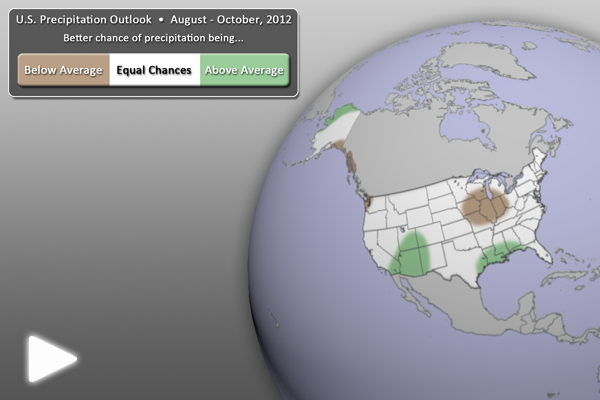
U.S. Precipitation Outlook (August-October 2012) • Click Image for Full-Earth animation • Click Here to open in YouTube

  • For the next three months (August – October), drier than normal conditions are expected for coastal Washington state, as well as the southeastern coastlines of Alaska. The mid-Mississippi River Valley can also expect continued below average precipitation, further exacerbating existing drought conditions.
  • Wetter than normal conditions are expected in the extreme southern portions of the desert southwest, likely due to increased monsoonal moisture. The southeast U.S. is also expected to be wetter than normal, due in part to warm waters in the Gulf of Mexico.
  • All other locations (in white) have equal chances of being wetter or drier than normal.
  • Outlook by NOAA’s Climate Prediction Center (CPC)
  • In its forecasts, the CPC uses a wide variety of models in conjunction with looking at climate variables (like El Niño).
  • It should be noted that areas be in the “drier than normal” region may still have rainy days. This outlook only suggests that after the three months are over, those areas in the “drier than normal” region are more likely to have experienced drier than normal averages.

Where do I find the datasets?

  • First, check your SOS system to make sure they are not already in the EarthNow category. There is also an earthnow.sos playlist file that includes a playlist with all of these datasets.
  • If not, you can download the datasets and playlist files from this FTP Site.

Helpful Resources for More Information

Credit(s):
Patrick Rowley, CIMSS/SSEC, UW-Madison
NOAA Climate Prediction Center
References:
NOAA Climate Prediction Center, 3-month Outlook Discussion, http://www.cpc.ncep.noaa.gov/products/predictions/90day/fxus05.html
NOAA Climate Prediction Center, 3-month Outlook Maps, http://www.cpc.ncep.noaa.gov/
Category: U.S. Outlook
Tags: , , , , , ,
0 Comments

June 2012 Fourth Warmest on Record

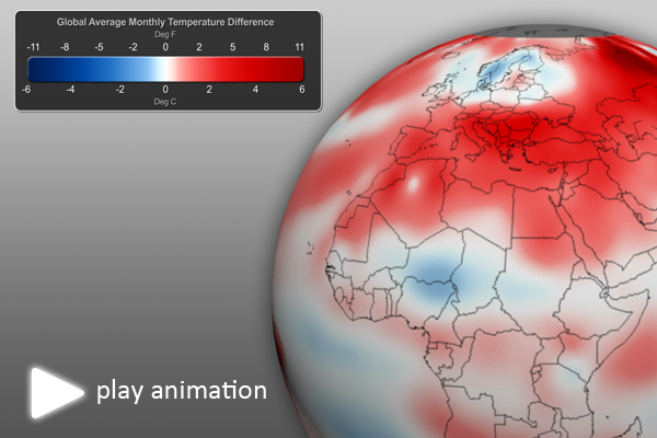
After the second warmest May on record, the combined global land and ocean temperature for June 2012 was 0.63°C (1.13°F) above the 20thcentury average of 15.5°C (59.9°F), making it the 4th warmest June on record (since 1880).

June 2012 Global Temperature Anomalies

June 2012 Global Temperature Anomalies • Animation link not work? Try here

Much of the well above-average land temperatures were concentrated on Earth’s land areas, making the June’s global land area the warmest on record (this was also the case for May 2012). Many land areas of the world experienced much warmer-than-average monthly temperatures, including much of Europe, Asia, northern Africa, most of North America and southern Greenland. Australia and northern Europe experienced notably cooler than average temperatures. Further, the Northern Hemisphere experienced its warmest combined land and ocean June temperature on record (this was also the case for May). The combined global land and ocean average surface temperature for January–June 2012 was the 11th warmest on record.

June 2012 also marks the 36th consecutive June and 328th consecutive month with a global temperature above the 20th century average.

Stay tuned for more June 2012 climate information in the coming days.

Helpful Resources for More Information

Credits:
Dan Pisut and Tim Loomis, NOAA Environmental Visualization Lab
Patrick Rowley, Cooperative Institute for Meteorological Satellite Studies
References:
NOAA National Climatic Data Center, State of the Climate: Global Analysis for June 2012, published online July 2012, retrieved on July 16, 2012 from http://www.ncdc.noaa.gov/sotc/global/2012/6.
Category: Climate
Tags: , , ,
1 Comment

May 2012 Climate Digest

Each month, we will provide information regarding the previous month’s climate. Overall, preliminary data analysis suggests that May 2012 was the 2nd warmest May on record (since 1880).  Major stories include a warm contiguous United States, cool Australia, and continued neutral conditions for El Niño and La Niña. More detailed information follows:

May 2012 Highlights

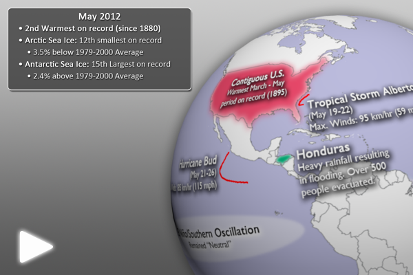
May 2012 Highlights • Click for Full-Earth animation

    • This dataset shows some of the major May climate highlights from the National Climatic Data Center’s (NCDC) monthly global climate analysis. The events are noted below with more information.
    • El Niño/Southern Oscillation (ENSO): Neutral (not El Niño or La Niña) conditions prevailed in the eastern tropical Pacific Ocean dissipated during April, giving way to neutral ENSO conditions. Click here for more information about ENSO and how it may impact the climate outlook for the coming months.
    • Hurricane Bud: With maximum sustained winds of 185 km/hr (115 mph), Bud was the strongest East North Pacific storm on record to form so early in the year. (May 21 – 26)
    • Australia: Well below normal, the average May minimum (low) temperature for Australia was the fifth coolest on record (since 1949).
    • China: In northwestern China, severe storms produced heavy rain and dangerous hail. (May 10)
    • Eastern Ethiopia: Flash floods caused significant crop damage. (May 2)
    • Austria: Austria experienced its seventh warmest March – May period on record. (since 1767)
    • Eastern Brazil: The worst drought in fifty years affected over 1,100 towns.
    • Honduras: Heavy rains resulted in flooding that forced the evacuation of over 500 people. The floods also damaged over 100 homes.
    • Tropical Storm Alberto: The first Atlantic tropical storm of the 2012 season was also the earliest-forming tropical storm in the Atlantic since 2003. The maximum sustained winds were 95 km/hr (59 mph). (May 19-22)
    • Contiguous United States: The U.S. experienced its warmest March – May period on record (since 1895).
May 2012 SST Anomalies

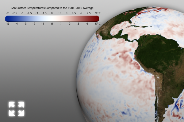
May 2012 SST Anomalies • Click for Full-Earth image

  • The real-time sea surface temperature anomaly dataset is a great way to visualize moderating water temperatures in the eastern tropical Pacific ocean. This helps show the warmer waters, indicating the loss of La Niña and transition to a neutral period.
  • Remember that the blues indicate cooler than average temperatures and reds indicate warmer than average temperatures (white: average).
May 2012 Global Temperature Anomalies

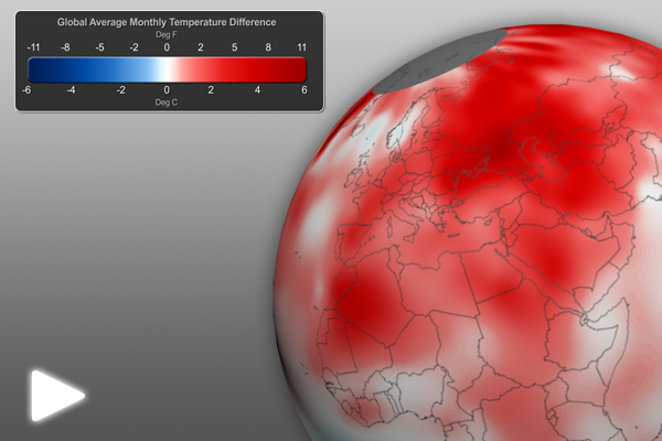
May 2012 Global Temperature Anomalies • Click for Full-Earth animation

  • Using the real-time Monthly Temperature Anomalies dataset is a great way to convey where some of the warmer and cooler than average areas were in May.
    • The combined global land and ocean average surface temperature for May 2012 was the 2nd warmest on record at 15.46˚C (59.79˚F), which is 0.66˚C (1.19˚F) above the 20th century average.
    • The combined global land and ocean average surface temperature for January–May 2012 was the 11th warmest on record.
    • Please see the “May 2012 Second Warmest on Record” post for more information.
May 2012 Snow and Ice

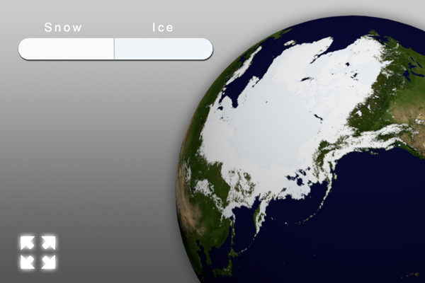
May 2012 Snow and Ice • Click for Full-Earth image

  • Aside from helping to illustrate seasonal changes, the real-time Snow and Ice Cover dataset is a great way to convey sea ice change through time, including discussing how the current sea ice extent compares to other noteworthy years.
  • The Arctic sea ice extent in May was 12th smallest on record. The extent was 3.5% below the 1979-2000 average.
  • In Antarctica, the April sea ice extent was the 15th largest on record, at 2.4% above the 1979-2000 average.
  • North America had its 8th smallest May snow cover on record (since 1967).
  • Eurasia had its smallest May snow cover on record (since 1967).

Where do I find the datasets?

  • First, check your SOS system to make sure they are not already in the EarthNow category. There is also an earthnow.sos playlist file that includes a playlist with all of these datasets.
  • If not, you can download the datasets and playlist files from this FTP Site.

Helpful Resources for More Information

References:
NOAA National Climatic Data Center, State of the Climate: Global Analysis for May 2012, published online June 2012, retrieved on June 19, 2012 from http://www.ncdc.noaa.gov/sotc/global/.
Category: Climate Digest
Tags: , , , ,
0 Comments