February Climate Digest

Each month, around the middle of the month, we will provide information regarding the previous month’s climate, as well as the U.S. seasonal outlook for the coming months. Overall, preliminary data analysis suggests that February 2012 was the 22nd warmest February on record. Major stories include a warm contiguous United States, a weakening La Niña, and bitterly cold temperatures in Eurasia. More detailed information follows:

February Highlights Graphic

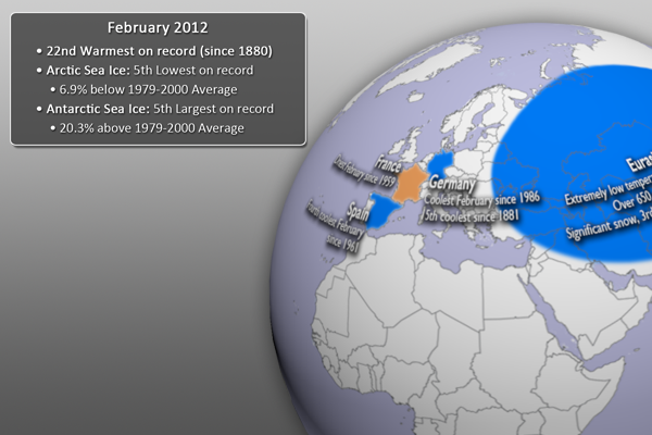
February 2012 Highlights • Click graphic for Full-Earth image

February 2012 Event Highlights

  • This dataset highlights some of the major February events from the National Climatic Data Center’s (NCDC) monthly global climate analysis. The events are noted below with more information.
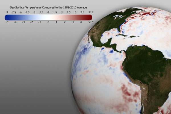
  • El Niño/Southern Oscillation (ENSO): The cooler than average waters in the eastern central Pacific Ocean have continued to moderate, signaling a very weak La Niña. ENSO is expected to become “neutral” by May 2012. Click here for more information about La Niña and how it may impact the climate outlook for the coming months.
  • Contiguous United States: Much of the country continued to experience very warm temperatures, resulting in the fourth warmest meteorological winter (December – February) on record (since 1895).
  • Argentina: East-central Argentina experienced very heavy rains. Rainfall in the city of General Pico totaled 339.4 mm (~13 in), breaking the previous February record of 276.4 mm (10.8 in), set in 1984.
  • Spain: Spain its fourth coolest February since 1961.
  • France: France had its driest February since 1959.
  • Germany: Germany experienced its coolest February since 1986 and the 15th coolest since records began (1881).
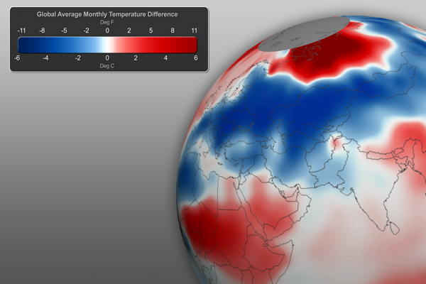
  • Eurasia: Much of the Eurasian continent experienced very cold temperatures from January 24th through February 14th. More than 650 deaths are blamed on the bitterly cold temperatures. Heavy snow also fell, resulting in the third largest February snow cover extent.
  • Cyclone Giovanna: (February 9-21, Max winds: 230 km/hr, 143 mph). Giovanna made landfall on the island of Madagascar on February 14th, bringing heavy rainfall, strong winds, and storm surge. The storm is blamed for 23 fatalities and leaving over 190,000 people homeless. For more information, see the last EarthNow blog post.
  • Australia: Australia had its 8th coolest minimum (low) February temperatures (coolest since 1990).
February SST Anomaly Graphic

15 February 2012 SST Anomaly • Click graphic for Full-Earth image

Sea Surface Temperature Anomaly

  • The real-time sea surface temperature anomaly dataset is a great way to visualize moderating water temperatures in the eastern central Pacific ocean. This indicates the weakening La Niña pattern mentioned above.
  • Remember that the blues indicate cooler than average temperatures and reds indicate warmer than average temperatures (white: average).
Monthly Global Temperature Anomaly Graphic

February 2012 Global Temperature Anomalies • Click graphic for Full-Earth image

Global Temperature Anomalies

  • Using the real-time Monthly Temperature Anomalies dataset is a great way to convey where some of the warmer and cooler than average areas were in February.
    • The combined global land and ocean average surface temperature for February 2012 was the 22nd warmest on record (and coolest since 2008) at 12.47˚C (54.57˚F), which is 0.37˚C (0.67˚F) above the 20th century average.
February Snow and Ice Cover Graphic

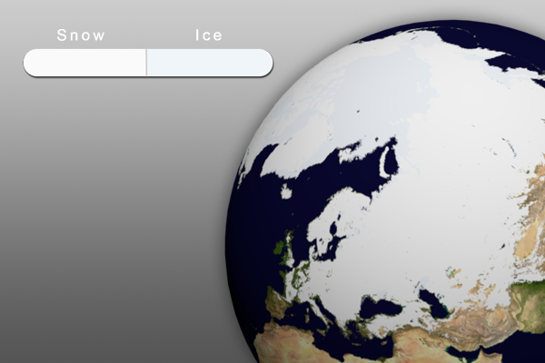
15 February 2012 Snow & Ice Cover • Click graphic for Full-Earth image

Snow and Ice…

  • Aside from helping to illustrate seasonal changes, the real-time Snow and Ice Cover dataset is a great way to convey sea ice change through time, including discussing how the current sea ice extent compares to other noteworthy years.
  • The Arctic sea ice extent in February was the fifth lowest on record. The extent was 6.9% below the 1979-2000 average.
  • In Antarctica, the January sea ice extent was the 5th largest on record, at 20.3% above the 1979-2000 average.
April - June Temperature Outlook Graphic

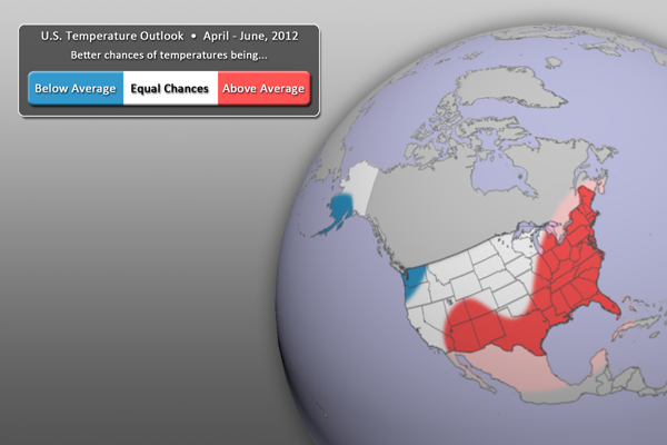
U.S. Temperature Outlook, April - June, 2012

  • Weakening La Niña conditions are expected to influence the U.S. temperature outlook (see below).
  • For the April – June period, warmer than normal temperatures are expected across much of the eastern third of the country, as well as the southern third.
  • By contrast, cooler than normal temperatures can be expected for the Pacific Northwest, north into southern Alaska.
  • All other locations (in white) have equal chances of being warmer or cooler than normal.
  • Outlook by NOAA’s Climate Prediction Center (CPC)
  • In its forecasts, the CPC uses a wide variety of models in conjunction with looking at climate variables (like La Niña).
  • It should be noted that areas in the “warmer than normal” region may still have cold winter days. This outlook only suggests that after the three months (April, May, and June) are over, those areas in the “warmer than normal” region are more likely to have experienced warmer than normal average temperatures. The same is true for the “cooler than normal” and “equal chances” regions.
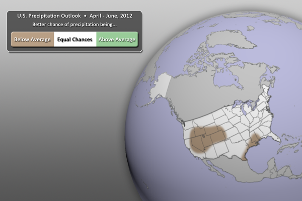
April - June Precipitation Outlook Graphic

U.S. Precipitation Outlook, April - June, 2012

  • For the next three months (April – June), drier than normal conditions are expected for parts of the western U.S. as well as along the western Gulf Coast.
  • Wetter than normal conditions are next expected anywhere.
  • All other locations (in white) have equal chances of being wetter or drier than normal.
  • Outlook by NOAA’s Climate Prediction Center (CPC)
  • In its forecasts, the CPC uses a wide variety of models in conjunction with looking at climate variables (like La Niña).
  • It should be noted that areas be in the “drier than normal” region may still have rain and snow storms. This outlook only suggests that after the three months (April, May, and June) are over, those areas in the “drier than normal” region are more likely to have experienced drier than normal averages. The same is true for the “wetter than normal” and “equal chances” regions.

Helpful Resources for More Information

Where do I find the datasets?

  • First, check your SOS system to make sure it’s not already in the EarthNow category. There should also be an ‘earthnow.sos’ playlist file (you’ll need to add that to your sosrc folder).
  • If not, you can download the datasets and playlist.sos files from this FTP Site.
Credits:
Dan Pisut, NOAA Environmental Visualization Lab
Kenneth Pelman, NOAA Climate Prediction Center
Matthew Rosencrans, NOAA Climate Prediction Center
Patrick Rowley, Cooperative Institute for Meteorological Satellite Studies
References:
NOAA Climate Prediction Center, http://www.cpc.ncep.noaa.gov/
NOAA Climate Prediction Center, Prognostic Discussion for Long-Lead Seasonal Outlooks, http://www.cpc.ncep.noaa.gov/products/predictions/90day/fxus05.html
NOAA National Climatic Data Center, State of the Climate: Global Analysis for February 2012, published online March 2012, retrieved on March 20, 2012 from http://www.ncdc.noaa.gov/sotc/global/2012/2.
Category: Climate Digest
Tags: , , , ,
0 Comments

Tropical Cyclone Giovanna

In mid-February, Tropical Cyclone Giovanna greatly impacted Madagascar, the fourth-largest island in the world, with high winds, storm surge, and heavy rain. After passing over the island one time, the storm turned around and made landfall again over the southern-most part of Madagascar, this time a much weakened storm. This EarthNow post will serve as a timeline of events to use in conjunction with the real-time satellite imagery datasets. We will also explore storm-related rainfall totals.

Tips on Using this Post within your SOS Presentation

  1. You could simply use the timeline information below with the existing real-time Infrared (IR) and/or Water Vapor (WV) datsets.
  2. As part of this post, there is also an IR playlist.sos file, which incorporates some PIP images, including higher resolution satellite images of Giovanna and even satellite imagery showing a sediment-clogged river after the storm. We have also included a storm-related rainfall totals PIP. This IR animation is focused on the dates of the storm.
  3. Further, we have included an IR playlist.sos file with red hurricane symbols placed at each of the mentioned locations in the timeline below. Please note that they will be visible throughout the entire IR animation, not just when Giovanna is visible. We are working hard to make this type of visualization more dynamic in the future! This IR animation is focused on the dates of the storm.
  4. But wait! There’s more… A third playlist.sos file includes both the Giovanna track symbols, as well as the PIPs mentioned in #2 above. This animation is also focused on the dates of the storm.
  5. So, to recap, you could simply use the information in the post along with the satellite datasets you already have in your playlist. Or, you could use one of the above-mentioned datasets to add more to the presentation. It’s all up to you! Let us know how you used the posts and playlist files.

 Tropical Cyclone Giovanna Timeline of Events

9 February 2012, 1500 UTC (10:00 am EST, 6:00pm local time)

  • Tropical Storm 12S
  • Maximum Sustained Winds: 40 mph (65 km/hr)
  • 794 miles (1,278 km) Northeast of La Reunion Island
  • 14.1˚S, 65.1˚E, moving West at 10 mph (16.7 km/hr)
  • Landfall in Eastern Madagascar expected on 13 February.

10 February 2012

  • Tropical Cyclone Giovanna (remember, hurricanes are called tropical cyclones in the Indian ocean)
  • Maximum Sustained Winds: 75 mph (120 km/hr), Category 1
  • 552 miles (889 km) Northeast of La Reunion Island
  • 15.8˚S, 61.2˚E, moving West-southwest at 9 mph (15 km/hr)
  • Expected landfall in East-central Madagascar on 13 February

13 February 2012, 1500 UTC (10:00 am EST, 6:00 pm local time)

  • Maximum Sustained Winds: 144 mph (232 km/hr), Category 4 (potentially catastrophic damage)
  • 288 miles (463 km) East of Antananarivo, Madagascar (Capital City)
  • 18.8˚S, 50.8˚E, moving West-southwest at 14 mph (22 km/hr)
  • Expected landfall in East-central Madagascar near dawn
  • Eastern Madagascar already experiencing gusty winds, rough surf, and rain
  • Eye: 35 miles (56 km) wide
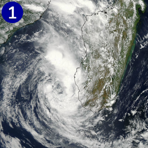
PIP1 - MODIS Image of Giovanna

credit: NASA

14 February 2012

  • Tropical Cyclone Giovanna made landfall just north of the the city of Vatomandry on the east coast of Madagascar during the early morning hours with winds up to 120 mph (194 km/hr), heavy rain, strong winds, and storm surge.
  • Vatomandry experienced a great deal of damage, with around 60% of the homes being damaged or destroyed, according to the BBC
  • The storm continued to track Southwest across Madagascar.
  • By afternoon (1200 UTC, 7:00am EST, 3:00pm local time), the storm had weakened considerably:
    • Maximum Sustained Winds: 40 mph (165 km/hr)
    • 115 miles (185 km) West of Antananarivo
  • 19.6˚S, 44.7˚E, moving West at 16 mph (26 km/hr)
    • PIP (SOS Picture In Picture) #1
      • The MODIS instrument captured this true color image of Giovanna just after the center of circulation moved off the west coast of Madagascar and into the Mozambique Channel

15 February 2012, 0300 UTC (10:00 pm 2/14 EST, 6:00 am local time)

  • Maximum Sustained Winds: 46 mph (74 km/hr), Tropical Storm
  • 288 miles (463 km) West-southwest of Antananarivo
  • 20.8˚S, 42.4˚E, moving West-southwest at 15 mph (24 km/hr)
  • In Mozambique Channel, expected to make another landfall in Momzambique
  • Wind shear hinders much restrengthening
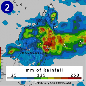
PIP2 - Rainfall

credit: NASA

  • Maximum Sustained Winds: 58 mph (93 km/hr)
  • 518 miles (833 km) East of Maputo, Mozambique
  • 24.5˚S, 40.7˚E
  • Estimatesd of up to 12 inches (~305 mm) of rainfall in Eastern Madagascar
      • Based on data from NASA’s TRMM Satellite (Tropical Rainfall Measuring Mission)
  • PIP (SOS Picture In Picture) #2
    • This NASA visualization shows the estimated rainfall from Giovanna between 8 February and 15 February.

17 February 2012, 1500 UTC (10:00 am EST, 6:00 pm local time)

  • Maximum Sustained Winds: 63.3 mph (102 km/hr)
  • 512 miles (824 km) SSW of Antananarivo
  • 25.8˚S, 43.2˚E, moving Southeast at 2.3 mph (3.7 km/hr)
  • Minor restrengthening expected before moving back over Southern Madagascar
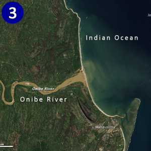
PIP3 - Sediment-clogged Onibe River

credit: NASA

  • PIP (SOS Picture In Picture) #3
  • Advanced Land Image (ALI) on NASA’s Earth Observing Satellite (EO-1), captured this image of a sediment clogged Onibe River in eastern Madagascar. The heavy rain caused the area rivers (which already have a very steep gradient) to erode even more than normal, causing lots of sediment to move out into the Indian Ocean.

 21 February 2012, 0300 UTC (10:00 pm 2/20 EST, 6:00 am local time)

  • Maximum Sustained Winds: 34.5 mph (55.5 km/hr)
  • 410 miles (670 km) Southeast of Antananarivo
  • 23.4˚S, 52.6˚E, moving NNW at 8 mph (13 km/hr)
  • After having moved over southern Madagascar, Giovanna continues final weakening in southern Indian Ocean
  • at least 23 fatalities
  • 190,000 people left homeless

That’s all for now. The next EarthNow post will the Monthly Climate Digest for February.

Where do I find the datasets?

  • First, check your SOS system to make sure it’s not already in the EarthNow category. There should also be an ‘earthnow.sos’ playlist file (you’ll need to add that to your sosrc folder).
  • If not, you can download the datasets and playlist.sos files from this FTP Site.
Credits:
Dan Pisut, NOAA Environmental Visualization Lab
Patrick Rowley, Cooperative Institute for Meteorological Satellite Studies
References:
NASA, Hurricane Season 2012: Tropical Cyclone Giovanna (Southern Indian Ocean), http://www.nasa.gov/mission_pages/hurricanes/archives/2012/h2012_Giovanna.html
Category: Tropical
Tags: , ,
1 Comment

EarthNow Topics and Stories

While the EarthNow team will continue to publish the global monthly climate digests each month, we want to make sure our other posts are covering topics and stories you are most interested in. There’s not a lot of sense in EarthNow publishing a story on the North Atlantic Oscillation if nobody is going to talk about it (it is interesting though. Read that entry if you haven’t yet). use the Comment Link below or the Contact Link above and let us know what kinds of topics you would like to see more of. It will be greatly appreciated. Thank you and Happy Beginning of Meteorological Spring!

Best Regards,

The EarthNow Team

Category: Project Information
Tags:
0 Comments