Several parts of the world have recently been experiencing drought conditions, the worst of which has been for much of the United States. Abnormally high temperatures this summer for most of the West and Central U.S. are indicative of an upper-level, high pressure system (ridge), which has been prevailing over a great part of the US throughout the summer. Further, the economic and societal implications that stem from these ongoing drought conditions are rather significant, with over 60% of the contiguous U.S. experiencing moderate to severe drought, and monsoonal rains in India being elusive, both negatively affecting crop yields. Through this post, we’ll explore recent drought conditions, the seasonal drought outlook, and societal impacts.

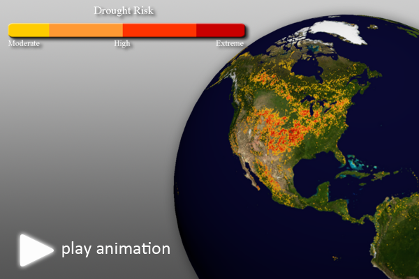
Global Drought Risk (NDVI) • Animation not work? Click here • Still Map Image
Global Drought Risk
- This real-time dataset should already be updating weekly on your Science On a Sphere (SOS) systems.
- This global drought risk composite is derived from the Normalized Difference Vegetation Index (NDVI) datasets developed by NOAA. By monitoring vegetation health, moisture and thermal conditions, scientists are able to identify areas that are considered to be vegetatively stressed due to drought. An important note is that the drought imagery is based solely on the analysis of vegetation health and stress, not soil moisture conditions. But this index serves as a reliable proxy measurement for drought worldwide. For more information about this dataset, visit the SOS site.
- The color scheme represents areas ranging from moderate to severe drought.
- As heat and a lack of rainfall has parched many of the most important commodity crops (wheat, soybeans, corn), the United States Department of Agriculture (USDA) announced on July 11 that more than 1,000 counties in 26 states qualified as natural disaster areas—the largest total area ever declared a disaster zone by the agency. Furthermore, wildfires in states such as Montana, Idaho and Nevada have turned grazing lands into blackened ground, significantly impacting cattle production and farming activities. Overall, the dry spell in the U.S. is now considered the worst since the 1950s.
- Millions of farmers in India are also experiencing losses due to drought conditions, due to elusive monsoonal rains. Right now, farmers can’t plant their rice patties because the soil to too dry and hard. India’s meteorological department has said that the June-August 1 rains have been about 19% below normal, and expects rainfall through September to be be about 10% below normal. Earlier this summer, La Niña gave way to neutral conditions, but many meteorologists expect an El Niño to develop was the northern hemisphere moves into Autumn, which could further exacerbate the drought conditions in India.
- Brazil has also experienced its worst drought in nearly 50 years.
 I also recommend taking a look at the Agricultural Intensity: Cropland dataset developed by the University of Minnesota’s Institute on the Environment, in conjunction with the Science Museum of Minnesota.

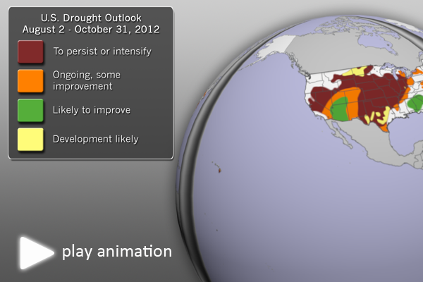
U.S. Drought Outlook (August-October, 2012) • Animation not work? Click here. • Still Map Image
U.S. Drought Outlook
- With so much of the country experiencing drought conditions, and with the potential for severe social and economic impacts, it’s important to provide some insight into the seasonal drought outlook for the United States.
- This dataset shows the NOAA Climate Prediction Center (CPC) U.S. drought outlook for August – October 2012. Note: Because this graphic is based on data only in the U.S., the SOS dataset shows the U.S. on three sides of the sphere.
- Much of the central and western parts of the U.S. are expected to have drought conditions persist or even intensify. Unfortunately, these are the areas with the most agricultural interest.
- With monsoonal moisture, some improvement is expected in the desert southwest. Thunderstorm clusters and tropical moisture may provide some spotty drought relief in parts of the east and southeast.
- Southern Texas and the northern plains are likely to see some drought development.
Why?
- So, that’s what’s happened and what may happen. Some of you, however, may want to know why the drought is so severe in the first place.
- Some research suggests that it may be due to decreased snowfall and precipitation in the spring, which allows the Sun’s energy to more efficiently dry out the soil. After the soil is dry, the energy can then more efficiently heat the air as well. Then, we get into a positive feedback mechanism in which the hot air leads to higher pressure, which then leads to no rainfall.
- Warm surface temperature anomalies, dominating most of the West and Central US are reflective of an upper-level, high pressure system (ridge), which has been prevailing over a great part of the US throughout June and part of July, 2012. Upper-ridge induced subsidence (downward, vertical air motion caused by upper-level convergence) has contributed to a suppression of convection and hence rainfall over most areas, such as the Southern Plains, parts of the Southeastern US, the Midwest and parts of the Pacific Northwest, as well as over the West coast and over several states in the Northeast. Clear skies and dry conditions have led to significant, positive surface temperature anomalies and low soil moisture conditions in these regions, resulting in the reinforcement of the upper level ridge and providing, thus, a positive (land-surface) feedback mechanism which in return contributes to augmented drying, well above-normal temperature anomalies and reduced soil moisture.
- For more information, take a look at this article.
Well, that’s all for now! The next big set of posts will be the July Climate Digest.
Where do I find the datasets?
- First, check your SOS system to make sure they are not already in the EarthNow category. There is also an earthnow.sos playlist file that includes a playlist with all of these datasets.
- If not, you can download the datasets and playlist files from this FTP Site.
Helpful Resources:
NOAA Climate Prediction Center, Seasonal Drought Outlook, http://go.wisc.edu/3zdhpc
NOAA National Climatic Data Center, State of the Climate: Drought for June 2012, published online July 2012, retrieved on August 2, 2012 from http://www.ncdc.noaa.gov/sotc/drought/2012/6.
Science Daily, Soil Moisture and Hot Days Examined Globally, http://go.wisc.edu/2z6rsg
U.S. Drought Monitor, http://droughtmonitor.unl.edu/


