2012 Atlantic Tropical Activity – Through 31 October

Atlantic Tropical Activity

Atlantic Tropical Activity • iPad Video

SOS Playlists

SOS Playlist
SOS AutoRun Playlist with Audio
Transcripts

Overview

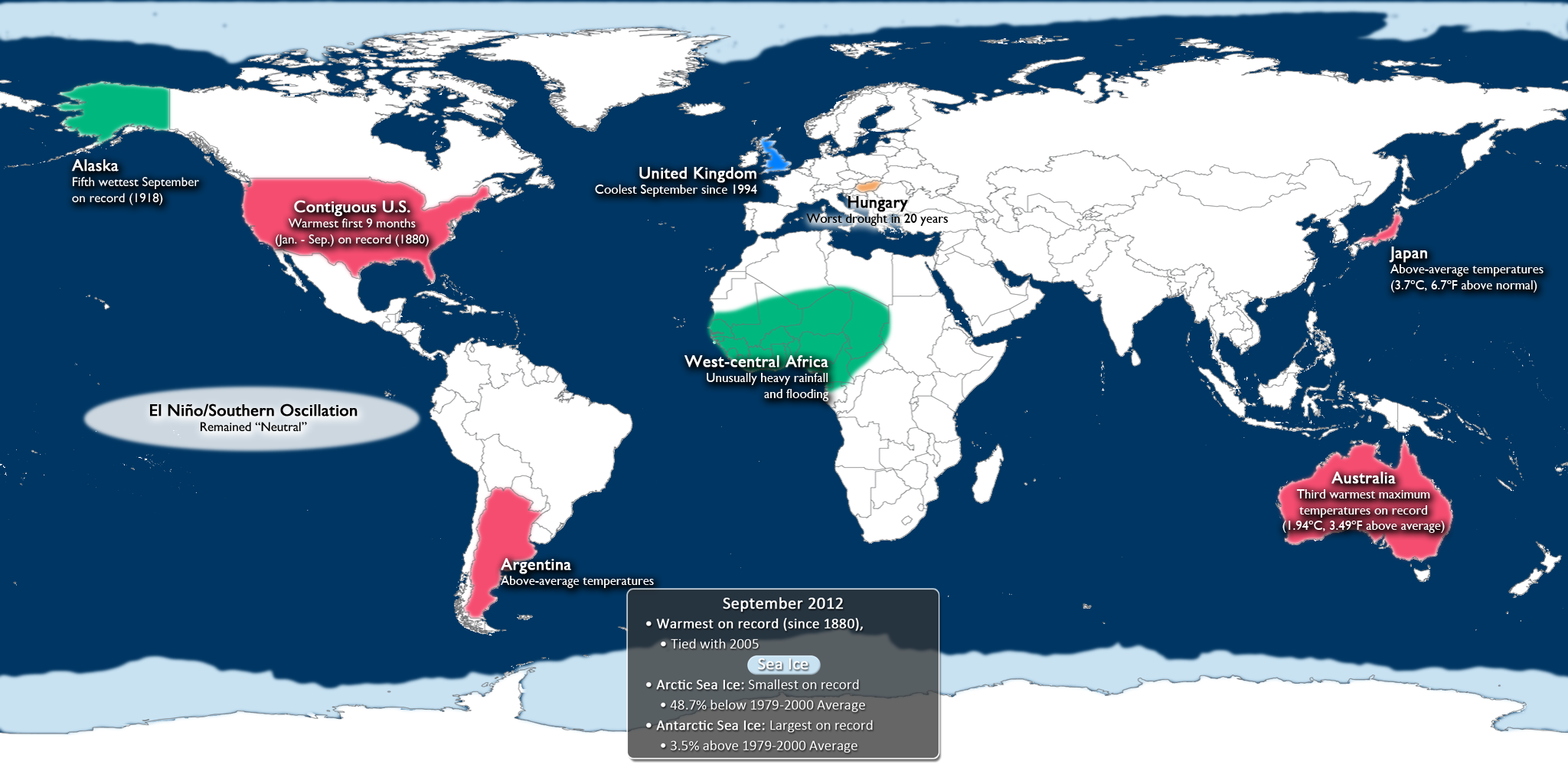
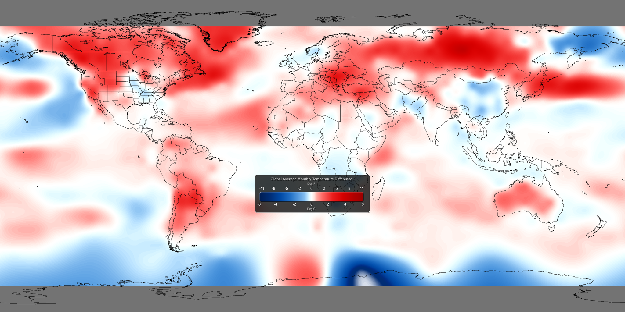
With the 2012 Atlantic hurricane season drawing to an end at the end of the month, we wanted to give you an update as to where we stand so far. 2012 has seen above-normal activity, with 19 names storms, 10 of which have developed into hurricanes, include the recent devastating Hurricane Sandy.

About the Dataset

Dataset Name: 20121029 EarthNow: Atlantic Tropical Update

This display shows the tracks taken by all named storms during the 2012 Atlantic hurricane season.

About Hurricanes

Atlantic Tropical Depressions originate in Western Africa and travel westward, steered by trade winds. The track a depression takes determines how it develops. Warm tropical water provides energy for a depression to grow into a Tropical Storm, and sometimes Hurricane. Moving out of the tropics over cooler water will cause a depression to lose energy and dissipate.

Hurricane Isaac

In late August, Hurricane Isaac intensified to Hurricane force over the warm Gulf of Mexico. As it moved over Louisiana, Isaac reached maximum winds of 80mph and made the Mississippi River flow backward for 24 hours, a rare event that last happened in 2005. Isaac caused $2B in damages, 41 deaths, and postponed the 2012 Republican National Convention.

Hurricane Sandy

In late October, Hurricane Sandy became the largest Atlantic hurricane with the lowest pressure ever recorded north of North Carolina. Its high winds spanned over 1,000 miles. Sandy rapidly intensified over the warm Caribbean Sea and tracked northward along the East Coast of the United States, affecting 24 states and causing destructive storm surge from New Jersey to southern New England. Sandy was blamed for more than $50B in damages and at least 170 deaths before it weakened after making landfall near Atlantic City, NJ.

Where do I find the datasets?
  • First, check your SOS system to make sure it’s not already in the EarthNow category.
  • If not, you can download the datasets and playlist files from this FTP Site.
  • Then download and use playlist files at the top of the page (or create your own) and make sure they are in /home/sos/sosrc or /home/sosdemo/sosrc.
Credits:
Visualizations/Blog: CIMSS, University of Wisconsin – Madison
Script/Blog: CICS-MD, University of Maryland
NOAA
References:
NOAA National Hurricane Center
Category: Tropical

3 Comments

September 2012 Climate Digest

September 2012 Climate Digest

September 2012 Climate Digest • iPad Video

SOS Playlists

SOS Playlist

Overview

Each month, we will provide information regarding the previous month’s climate. Overall, preliminary data analysis suggests that September 2012 was tied with 2005 as the warmest on record (since 1880).  Major stories include a warm first 9 months for the contiguous United States, warmer than normal Australia, flooding in western Africa, and continued neutral conditions for El Niño and La Niña. More detailed information follows.

Septermber 2012 Highlights

Sphere Preview • iPad Video

Highlights Dataset

Dataset Name: 20121023 EarthNow: September 2012 Highlights
Full Map Image
  • This dataset shows some of the major September weather and climate highlights from the National Climatic Data Center’s (NCDC) monthly global climate analysis, and serves as an overview of what can be discussed in the datasets that follow. Highlights are noted below with more information.
  • Contiguous United States: Warmest first nine months (January-September) on record.
  • Alaska: Fifth wettest September on record (since 1918)
  • El Niño/Southern Oscillation (ENSO): Neutral (not El Niño or La Niña) conditions prevailed in the eastern tropical Pacific Ocean. It should be noted, however, that water temperatures in the region are above normal, just not to the El Niño threshold. See the “SST Anomalies Dataset below” to see the data. Click here for more information about ENSO and how it may impact the climate outlook for the coming months.
  • Japan: Record warmth in September with temperatures 3.7˚C (6.7˚F) above average. Southern Japan is not included in this, as a super typhoon impacted that region, affecting temperatures.
  • Australia: Third warmest September maximum (high) temperatures on record (since 1950) (1.94˚C, 3.49˚F above average)
  • Africa: Heavy rainfall and deadly flooding impacted parts of western and central Africa.
  • Hungary: Severe drought impacted parts of central Europe, including Hungary which experienced its worst drought in 20 years.
  • United Kingdom: Coolest September since 1994.
  • Argentina: Warmest September temperatures in 50 years.
  • Arctic Sea Ice: Smallest September extent on record (48.7% below 1979-2000 average)
  • Antarctic Sea Ice: Largest September extent on record (3.5% above 1979-2000 average)
September 2012 Global Temperature Anomalies

Sphere Preview • iPad Video

Global Temperature Anomalies Dataset

Dataset Name: 20121023 EarthNow: RT Monthly Temperature Anomalies
Full Map Image
  • Using the real-time Monthly Temperature Anomalies dataset is a great way to convey where some of the warmer and cooler than average areas were in September, including those mentioned above in the highlights.
  • The combined global land and ocean average surface temperature for September 2012 was tied with 2005 as the warmest on record (since 1880).
  • Please see the “September 2012 (and 2005) Warmest on Record” post for more information.
September 2012 SST Anomalies

Sphere Preview • iPad Video

Sea Surface Temperature Anomalies Dataset

Dataset Name: 20121023 EarthNow: RT SST Anomalies
Full Map Image
  • The real-time sea surface temperature anomaly dataset is a great way to visualize the El Niño – Southern Oscillation (ENSO) cycle in the eastern tropical Pacific ocean. This helps show the moderating water waters, indicating the loss of La Niña and potential transition to an ENSO Neutral period.
  • Remember that the blues indicate cooler than average temperatures and reds indicate warmer than average temperatures (white: average).
September 2012 Snow and Ice Cover

Sphere Preview • iPad Video

Snow and Ice Cover Dataset

Dataset Name: 20121023 EarthNow: RT Snow and Ice Cover
Full Map Image
  • Aside from helping to illustrate seasonal changes, the real-time Snow and Ice Cover dataset is a great way to convey sea ice change through time, including discussing how the current sea ice extent compares to other noteworthy years.
  • The Arctic sea ice extent in September was the smallest on record. The extent was 48.7% below the 1979-2000 average.
  • In Antarctica, the August sea ice extent was the largest on record, at 3.5% above the 1979-2000 average.
Where do I find the datasets?
  • First, check your SOS system to make sure it’s not already in the EarthNow category.
  • If not, you can download the datasets and playlist files from this FTP Site.
  • Then download and use playlist files at the top of the page (or create your own) and make sure they are in /home/sos/sosrc or /home/sosdemo/sosrc.
Helpful Resources for More Information
Credits:
Visualizations/Blog: CIMSS, University of Wisconsin – Madison
Script: CICS-MD, University of Maryland
NOAA
References:
NOAA National Climatic Data Center, State of the Climate: Global Analysis for September 2012, published online October 2012, retrieved on October 22, 2012 from http://www.ncdc.noaa.gov/sotc/global/2012/9.
Category: Climate Digest
Tags: , , , , , ,
2 Comments

U.S. Early Winter Outlook

SOS Playlist

icon_playlist SOS Playlist

Overview

NOAA’s Climate Prediction Center expects that for the early part of winter, only the southern portion of Florida will experience below normal temperatures on average. Other parts of the country may experience above normal temperatures or average conditions.

U.S. Temperature OutlookU.S. Temperature Outlook

Still Map Image
    • Sea Surface Temperatures in the ENSO (El Niño Southern Oscillation) region suggest continued neutral conditions, according to NOAA’s Climate Prediction Center.
    • For the November – January period, warmer than normal temperatures are expected for much of Alaska, as well as much of the western plains and Rocky Mountains. Only the southern half of Florida is to expect cooler than normal conditions.
    • All other locations (in white) have equal chances of being warmer or cooler than normal.
    • Outlook by NOAA’s Climate Prediction Center (CPC)
    • In its forecasts, the CPC uses a wide variety of models in conjunction with looking at climate variables (like El Niño).
    • It should be noted that areas in the “warmer than normal” region may still have cooler than normal days. This outlook only suggests that after the three months are over, those areas in the “warmer than normal” region are more likely to have experienced warmer than normal average temperatures.

U.S. Precipitation OutlookU.S. Precipitation Outlook

Still Map Image
  • For the next three months (November – January), drier than normal conditions are expected for the Pacific Northwest, as well as for a central portion of the country, expanding from Minnesota south to northern Arkansas and Oklahoma.
  • Wetter than normal conditions are expected in the extreme Southeastern U.S., as well as northern Alaska.
  • All other locations (in white) have equal chances of being wetter or drier than normal.
  • Outlook by NOAA’s Climate Prediction Center (CPC)
  • In its forecasts, the CPC uses a wide variety of models in conjunction with looking at climate variables (like El Niño).
  • It should be noted that areas be in the “drier than normal” region may still have rainy days. This outlook only suggests that after the three months are over, those areas in the “drier than normal” region are more likely to have experienced drier than normal averages.
Where do I find the datasets?
  • First, check your SOS system to make sure it’s not already in the EarthNow category.
  • If not, you can download the dataset and playlist files from this FTP Site.
  • Then download and use playlist file(s) at the top of the page (or create your own) and make sure they are in /home/sos/sosrc or /home/sosdemo/sosrc.
Helpful Resources for More Information
Credit(s):
Visualizations/Blog: CIMSS, University of Wisconsin – Madison
NOAA
NOAA Climate Prediction Center
References:
NOAA Climate Prediction Center, 3-month Outlook Discussion, http://www.cpc.ncep.noaa.gov/products/predictions/90day/fxus05.html
NOAA Climate Prediction Center, 3-month Outlook Maps, http://www.cpc.ncep.noaa.gov/
Category: U.S. Outlook
Tags: ,
1 Comment